Cannon Heritage Consultants provides a diverse and complete range of Historic Preservation and Cultural Resource Management services. Our offices can deliver state-of-the-art and cost effective archaeological, architectural, and historic investigations to our clients.

The following is a list of specific CRM service areas and niche specialties CHC can provide:

Archaeological Surveys

CHC’s archaeologists have extensive experience in the conduct of archaeological survey, site inventory, and assessment for projects that trigger the Section 106 and Section 110 processes of the National Historic Preservation Act. Our archaeologists have worked within a wide range of environmental circumstances and are experts in the following aspects of Phase I level archaeological survey:

  • Review of local documents, maps, and historic records
  • Coordination with management personnel and landowners
  • Corridor and linear studies
  • Predictive modeling
  • GPS and GIS mapping
  • Geophysical prospecting
  • Remote sensing with LiDAR and high ­resolution aerial imagery
  • Deep site testing

CHC is well-equipped to continue the Section 106 process through Phase II and Phase Ill level archaeological survey through site testing and National Register eligibility determinations. Senior staff at CHC is well versed in the NEPA and Section 106 processes, and have the talent and experience to develop Historic Properties Management Plans, Programmatic Agreements, and MOAs/MOUs, as well as develop alternatives such as avoidance and public participation.

Selected projects include:

A Class III Cultural Resources Inventory for the Cedar Mountain Area, U.S. Army Dugway Proving Ground, Tooele County, Utah

Cultural Resource Inventory for Idaho Power Line 850 Relicensing, Midpoint to Borah, Southeast Idaho

Cultural Resource Inventory Along The North Shore of Lima Reservoir, Beaverhead County, Montana

Class III Cultural Resources Inventory for the Skull Valley Land Exchange, Toole County, Idaho

Alta Special Use Permit Survey: Mining and Skiing History, Salt Lake County, Utah

Bullion Canyon Fuels Mitigation Survey, Piute County Utah

Canyonlands White Rim Road, San Juan County, Utah

Central Pacific Railroad Feature Survey, Box Elder, Utah

Dinosaur National Monument Grazing Survey, Moffat County, Colorado

Echo Park Survey, Dinosaur National Monument, Moffat County Colorado


Data Recovery

Data Recovery is implemented when significant archaeological sites cannot be protected from development or construction projects. To compensate, in part for the loss and destruction, recovery of artifacts through excavation is offered as an alternative. An initial step in this process is the development of a Data Recovery Plan that details the procedures and protocol for the excavation, sampling, and analysis of recovered artifacts. CHC archaeologists are skilled in the development and execution of research designs and data recovery plans. Our team represents some of the leading scholars in the human history of the lntermountain West through their research and publications, and membership in professional organizations.

Selected projects include:

An Historic Properties Treatment Plan for the Skull Valley Land Exchange, Tooele County, Utah

The Results of Archaeological Investigations at Three Sites along the Wilson-Fall Creek Road Corridor, Teton County, Wyoming

Archaeological and Paleoenvironmental Investigations at the Cove Creek Site (10LH144), Salmon-Challis National Forest, Idaho

Results of Archaeological and Paleoenvironmental Investigations along the North Shore of Yellowstone Lake, Yellowstone National Park, Wyoming

Data Recovery at 26EK16689, A Multicomponent Site, Wendover Airport, Elko County, Nevada

Geographic Information Science

CHC has a fully functioning geospatial laboratory with the goal of providing state-of­-the-art spatial analysis, modeling, and visualization services in cultural, social and behavioral studies. The lab provides multi­scalar precision mapping services from the artifact to landscape levels. We employ a full suite of survey instruments including robotic total station, survey grade GPS, and Geographic Information System. We aid in Geographic Information Science projects from project conception and design stages through development and completion. We are able to collect, compile, analyze and visualize spatial data through the use of these precision mapping tools and integrate data collected through LiDAR and geophysical survey. Our people work closely with the archaeological community to develop innovative strategies for documenting the archaeological record. We incorporate magnetometer and ground penetrating radar (GPR) survey with traditional archaeological site mapping to identify areas of potential interest that can be used for cultural resource management proposes including the refinement of sampling and testing strategies. The efficiency gained from integrating GIS and our multiple mapping techniques provides a cost savings to our clients.

GIS provides a tool to compile and manage spatial data generated from our various instruments. We have the capabilities of delivering GIS data in an array of presentation formats; including paper production, ESRI geodatabases, shapefiles or interchange files (.eOO), and ESRI ArcMap (9.0 and higher) documents. We can tailor GIS construction for specific client needs and present deliverables for those who do not have access to ESRI ArcGIS products through the use of ArcReader. This free software provides access to GIS data in an interactive environment where users are able to design queries and print documents from the compiled GIS data provided through our services. All our data are delivered to client defined standards with regards to coordinate system, projection, feature attributes and metadata.

Selected projects include:

Sensitivity Model for Archaeological Resources Skull Valley Land Exchange, Tooele County, Utah

GIS Coordinator for the Grand Canyon National Park Geoarchaeological Project

Jerry Peak Archaeological and Fire Management Assessment Study. Submitted to the Salmon Field Office, Bureau of Land Management, Idaho

National Park Service Midwest Region Native American Graves Protection and Repartriation Act GIS

Historic Trails of Nebraska Web-Based Geographic Information System

Hot Springs National Park Cultural Resource Geographic Information System

Site Sensitivity Model for Dinosaur National Monument Grazing Survey, Moffat County, Colorado

Using GIS for a Central Pacific Railroad Risk Assessment employing an Analytical Hierarchy Process Model and Weighted Sum Overlay Analysis, Box Elder County, Utah

Geomorphology and Site Formation Processes

Staff members at CHC are trained and have worked extensively with field geologists in understanding land forms and the processes associated with site formation. We have collaborated extensively with William Eckerle of Western GeoArch Research in the investigation of site formation processes and the geomorphic setting of archaeological sites in Idaho and elsewhere in the lntermountain West.

Selected studies include:

Final Report for Testing/Reevaluation of Archaeological Sites in the North Training Area, Camp Guernsey, Platte County, Wyoming

Post-Glacial Inflation-Deflation Cycles, Titling, and Faulting in the Yellowstone Caldera Based on Yellowstone lake Shorelines

Geoarcheological Investigations of the Crescent H Ranch Site (48TE1079), Teton County, Wyoming

Geophysics and Remote Sensing

CHC is able to offer geophysical prospecting through the use of three instruments. A Fluxgate Gradiometer is used to provide magnetometer survey. This form of geophysical survey provides imaging beneath the ground surface of approximately 1m. Magnetometer surveys have been profitable for locating cultural anomalies that are of interest to archaeologists in both historic and prehistoric contexts. A resistivity meter is also used in conjunction with a magnetometer to provide a second line of evidence of likely cultural anomalies below the ground surface. Finally, Ground Penetrating Radar (GPR) is used to provide a time series and greater depth to subsurface visibility. The GPR survey provides a reading of disturbances in the soils that are not always depicted with magnetometer or resistivity analysis. These lines of assay provide a unique management tool to our clients that can facilitate and guide testing procedures to areas likely to contain archaeological resources.

Selected reports and publications include:

Archeological Investigations: Bear River Massacre National Historic Landmark, Franklin County, Idaho

Final Report for Testing/Reevaluation of Archaeological Sites In The North Training Area, Camp Guernsey, Wyoming

Cultural Resources Inventory Along the North Shore of Lime Reservoir, Beaverhead County, Montana

Evaluative Testing Results at Site 42SL627, Utah National Guard Salt Lake Readiness Center, Salt Lake County, Utah

Testing at Three Sites on The Utah National Guard Camp Williams Reservation, Utah County, Utah

Comparison of Fuzzy Clustering Methods and Their Applications to Geophysical Data

Archaeological Investigations:

Utah National Guard Salt Lake Readiness Center, Salt Lake County, Utah

Camp Williams, Utah County, Utah

Bear River Massacre National Historic Landmark, Franklin County, Idaho

North Training Area Camp Guernsey, Platte County, Wyoming

Ground Penetrating Radar Survey of Site 26Ek16689, A Multicomponent Site, Wendover Airport, Elko County, Nevada

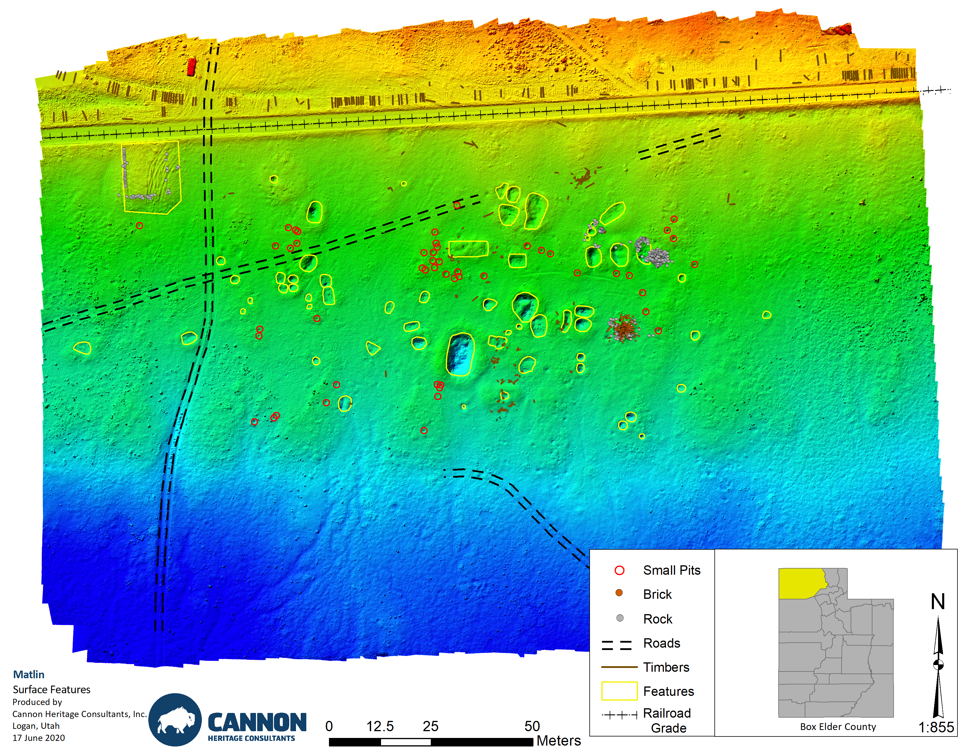
Ground Penetrating Radar Survey of Selected Areas at the Central Pacific Railroad Communities of Matlin and Terrace, Box Elder County, Utah

Magnetic Gradiometer Survey of Two Potential Grave Sites along the Central Pacific Railroad Grade, Box Elder County, Utah

Historic Building and District Documentation

CHC has collaborated with Ron Sladek of Tatanka Historical Associates to provide consultation and compliance services for historic architecture. Ron holds an MA from the University of Colorado Boulder and has over 20 years of experience in the field of historical writing, research, resource analysis, consultation, and education. Since 1992 Ron has conducted nearly 100 projects for private, local, state, tribal, and federal clients. Ron possesses the ability to conduct Historic American Building Survey (HABS) and Historic American Engineering Record (HAER) research and documentation. His education and experience meets the Secretary of Interior’s Professional Qualification Standards (48FR44716).

Services provided include:

  • Site and district survey and analysis, including photography, field recording, and archival research
  • Section 106/NEPA documentation and analysis
  • Nominations for historic building, structure, site and district designations through local landmark programs and through State and National Registers of Historic Places
  • Grant writing for State Historical Fund and CLG planning and preservation grants
  • Preservation planning and the development of interpretive materials and site assessments
  • Strategic project consulting for any type of preservation effort
  • Liaison work between development teams and regulatory agencies
  • Lectures, writing and tours on historic themes and preservation issues

Inundation Studies

The impact on archaeological deposits from inundation is a concern for land managing agencies. CHC has a staff that is uniquely qualified to address these concerns. In most circumstances, the effect of the generation of electricity through hydropower invokes the Section 106 process. Several of our senior staff has been directly involved in the study of impacts of inundation on cultural resources.

Our current work in Grand Canyon National Park is the most recent:

Grand Canyon Geoarchaeological Project: 2010 Workplan for Five Cultural Properties in the Grand Canyon National Park

Spatial Analysis of Cultural and Natural Distributions of Artifacts at the Lawrence Site, Jackson Lake, Wyoming, Investigating Inundated Deposits

LiDAR and High Resolution Aerial Imagery

LiDAR (Light Detection and Ranging) is an optical remote sensing technology that measures properties of scattered light to find range and/or other information of a distant target. LiDAR has many applications for archaeology through the creation of high ­resolution digital elevation models (DEMs) of landforms and archaeological sites that are otherwise concealed by vegetation. This information can be used to detect ‘hidden’ archaeological features. Ground-mounted LiDAR units can also be used to create DEMs of standing structures, rock art sites, rockshelters and caves. LiDAR can produce high-resolution datasets quickly and relatively inexpensively and can be seamlessly integrated in a GIS for analysis and interpretation.

The LiDAR system is accompanied by a 22 megapixel color camera that will simultaneously acquire imagery on both fixed-wing and helicopter platforms. This imagery can be acquired at triple the pixel resolution of LiDAR. The imagery can be geometrically corrected for distortions and orthorectified using both the LiDAR terrain model and positioning information from the Novatel navigation system, supported with minimal or no ground control. The rectified images can be mosaicked and color adjusted (feathered) to provide minimal image discontinuities and the edge of individual frames. The nominal orthoimage pixel size is matched to the nominal resolution of the original imagery. The size and number of the orthorectified blocks that could be delivered can be customized. The result is an orthophotograph with ground resolution ideal for the identification of archaeological features and artifacts including canals, trails, roads, pithouses, and stone circles.

Matlin Section Station DEM

Zooarchaeology and Mammalian Biogeography

Zooarchaeology and mammalian biogeography represent crucial studies in understanding the relationship between humans and animals as view from the archaeological record and the changes in mammalian range and behavior within a historic context. CHC provides the expertise in the identification and interpretation of faunal remains recovered from archaeological sites.

Selected publications:

Bison Hunting in Jackson Hole, Wyoming: Evidence from the Goetz Site (48TE455)

The Ecology of Early Holocene Bison in The Greater Yellowstone Ecosystem, Wyoming: Preliminary Results from The Horner Site

They Went as High as They Chose: A Case Study on the Ecology of High Altitude Bison Remains from the Uinta Mountains, Utah

Zooarchaeology and Conservation Biology

Applied Zooarchaeology, Because It Matters

Zooarchaeology and Wildlife Management in the Greater Yellowstone Ecosystem

What the Past Can Provide: Contribution of Prehistoric Studies to Modern Bison Management

Rodent and Badger Remains from Terminal Pleistocene-Holocene Deposits in Southern Jackson Hole, Wyoming

A Review of Archeological and Paleontological Evidence for the Prehistoric Presence of Wolf and Prey Species in the Northern and Central Rockies Physiographic Provinces

Chapter 11: A Reflection on the Application of Archeology to the Understanding of the History and Ecology of Holocene Bison in the Greater Yellowstone Ecosystem. In Discs, Fish, Squirrels, and Scat

Papers in Honor of Walter Klippel, edited by Meagan Elizabeth Dennison, Jennifer Green, Samantha Upton. University of Tennessee Press, Knoxville (in press)

An Archaeologist’s View: Knowing the Data. A Commentary on Keigley (2019) and Beschta and Ripple (2019).